
Back on April 26th, along with some good friends, we hiked The Appalachian Trail (AT) from Clingmans Dome, elevation 6,643 feet, down to Newfound Gap, elevation 5048. Clingmans Dome, in the Great Smoky Mountains NP, marks the highest point along the AT from Georgia to Maine. While that hike was much more difficult than we thought it would be, it is one of our all-time favorite hikes!!! It’s also the hike that taught us to check elevations charts before we start a hike;o))
Today, we decided to hike UP to a summit along the Appalachian Trail :o))
At 4458 feet elevation,
Blood Mountain Summit is the Appalachian Trail’s highest ascent in Georgia.
There are several routes to the summit,
so we studied them and choose a route that starts at the Byron Herbert Reese Trailhead (P).
The Byron Herbert Reese Trail is marked in Green.
The Appalachian Trail is marked in Yellow.
The Freeman Trail is marked in Blue.
The Blood Mountain Summit is marked in Orange.

Our hike will be a lollipop shaped hike…
Byron Herbert Reese (Green) Trail for .7 miles to the Freeman (Blue) Trail for 2 miles to the Appalachian (Yellow) Trail for 2.6 miles and back down the Byron Herbert Reese (Green) Trail for .7 miles. It was supposed to be about a 6 mile hike. However, when we finished, our GPS said we had hiked 9 miles??
We could have done a much shorter hike directly to the summit, but those switchbacks are very steep and we (I) decided we would rather come down them. Also, very few people do the loop trail. Actually, we never saw anyone on the Freeman Trail;o))
Elevation chart for our hike. We started at 3000 feet and climbed to 4458 feet over 4 miles.
 We started at 3000 feet and climbed to 4458 feet over 4 miles.
Our descent back to 3000 feet was over 2 miles!!
Click on any photo to enlarge or hover your mouse on any photo for a description
This is where we are headed…

Why is it called Blood Mountain?
Blood Mountain was the sight of a battle between Cherokee and Creek Tribes for control of territory. The Cherokees won the battle, which was fought at Slaughter Gap between Blood Mountain and Slaughter Mountain. Both Slaughter Gap and Slaughter Mountain are called such due to the tragic fight between the two tribes.
OK, Let’s Get Going….
The trailhead is located half a mile north of the Walasi-Yi center at Neal’s Gap along US 19.


The first .7 miles are along the Byron Herbert Reese Trail (Green Trail)
The trail starts off level along a small creek,
then it begins to climb along several steep switchbacks.


Click on any photo to enlarge or hover your mouse on any photo for a description


The trail continues to climb to an elevation of 3400 feet.


The Byron Herbert Reese Trail ends at Freeman Gap and the junction of the AT and the Freeman trail. From here, turning right on the AT is the shortest and most direct route to the top of Blood Mountain; however, it is also the steepest. Turning left along the AT will take you back to Neal’s Gap and US 19.


Narrow, Rocky, and Challenging!!!


We just took our time, were very careful and had a BALL !!!
We love hiking over the rocks:o))
We think it would be better to hike this trail in the spring before the trees get their leaves.


We got some peeks at the views along the trail.


All along the Freeman Trail, there were lots of boulders and obstacles to negotiate…


OOPS… One of those obstacles won ;o((

At Bird Gap, the Freeman (Blue) Trail rejoins the Appalachian (Yellow) Trail. 


Turning right, the AT (yellow) trail continues to Slaughter Gap…

the start of the 1 mile climb to Blood Mountain summit.

The first half of the 700 foot ascent is slightly steeper than second half, 

but no part of this section of the trail is flat ;o((
There was only one way we were going to accomplish this ascent…


UP…. UP…


REST !!!

UP…. UP…


REST !!!

Bill was very patient :o))
Uphill is not my thing and he does quite well going up.
So we would hike until I said rest!!
We did that over and over… up, up rest… up, up, rest!!
Finally, we were going up and around a corner….
WOO HOO…
there was the CCC Shelter at the SUMMIT :o)))))

Blood Mountain Shelter was constructed by the Civilian Conservation Corps in 1934.
This 2-room stone building is an iconic symbol of the AT in Georgia.
It is listed on the National Registry of Historic Places.
Click on any photo to enlarge or hover your mouse on any photo for a description


For our Acadia hiking buddies…


Could this be Trail Magic ???
A pair of boots left for someone who might need a pair :o))

As we stepped back out the entrance, we saw the view to the Northeast…

It was hazy and blue,
but we could barely make out the Brasstown Bald tower where we stood yesterday ;o))
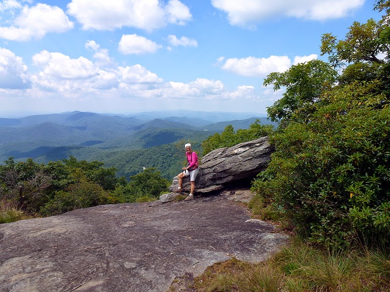
Right next to the shelter, 

are some nice rock outcroppings where we decided to have lunch!!
There was no way Bill would go up on the BIG rock:o((
However, there was a wonderful patio rock just in front of it:o))
Perfect lunch spot with a magnificent view !!!


By now, we had been on the trail for over four hours and not seen another person:o))
All of a sudden, we hear a great commotion on the rock above us?!?!
We stood up to see what was going on and about scare this group of servicemen to death!!!
They had no idea we were down below;o))

They asked Bill to take their photo with the American Flag and I got my photo also!!!
We enjoyed our lunch spot a bit longer, but it was time to get going DOWN the mountain.
While I struggle with the uphill climb,
I love the DOWN:o))
So we saved the steepest route for our descent.

Now it’s time to tackle those steep switchbacks !!!
As you leave the summit, you cross a smooth rock bald.

Pretty views along this section.
We watched an Osprey soaring high overhead!!

In a short distance,
the nice flat rock face turned to a steep descent ;o((

We proceeded very carefully!!


After that challenging down hill section,
the trail was a nice walk through the woods:o))


Then we reached the steep rocky switchbacks!!
I’ll let the pictures tell the story….
Click on any photo to enlarge or hover your mouse on any photo for a description


For our Acadia hiking buddies…
This switchback section of the hike was steeper than any descent we made in Acadia.
Bill never once did any Butt Hiking;o)
He has really made great strides in dealing with his fear of heights!!!
After the switchbacks,
it was a short hike to the Byron Herbert Reese (Green) Trail.


We made a left on the BHR trail and retraced our steps to the parking area.


This was a wonderful hike.
It wasn’t easy, but it was marvelous!!!
Hiking the AT is a Blast :o)))
You youngsters are wearing me out! :) That looked like a 2 walking stick hike for me!!
ReplyDeleteThat was a hike up a minor hill compared to the mountain Sherry and David just hiked up (to your lake). :cD
ReplyDeletePS: It was beautiful, none the less!
Wow what a great hike. This post made me feel like I was right along with you. Looks every bit as challenging as the ones we've done here with the rocks. We're just at a higher elevation. Way to go Bill, no butt hiking. Glad to see pictures of you Nancy. You did have me confused when you'd say the AT (yellow). I kept thinking but the AT is white, then DUH.......your great map had to make it yellow, we couldn't see it if it was white. LOVE your maps.
ReplyDeleteThat looks like a great hike and beautiful views.
ReplyDeleteGood for you! Come on Bill... that rock was perfect for having lunch!
ReplyDeleteThat certainly was a challenging but beautiful hike, and your wonderful blog post was worth the wait!
ReplyDeleteWe really need to get in better hiking shape and do that trail. I bet it will be beautiful in the fall with all the fall foliage.
Looks like one heckuva great hike! Great job on no butt hiking, Bill! Cool trail magic!
ReplyDeleteGreat hike! Beautiful scenery!
ReplyDeleteAwesome! Mark another section off the AT trail map. Love that "Trail Magic'.
ReplyDeleteLooks like a great hike -- one that the boys would love, all that rock climbing!!
ReplyDeleteMy kind of hike, and I think you're right about spring not just because of the views but the spring wildflowers too.
ReplyDelete